The Department of Public Works has three projects scheduled to start next week, the first week of October.
Work hours for all three projects are 7 a.m. to 7 p.m. We appreciate everyone’s patience and understanding during this work.
- Starting Monday, Oct. 3 – On streets across the city (likely to start around Piper Park, off Broad Street) – A city contractor will televise the sanitary sewer system, a maintenance activity that puts a camera into the sanitary sewer pipes to check for repair and maintenance needs.
Streets will stay open. Please watch for the crews and obey all road signs where they are working.
This work is ongoing, and does not yet have an end date.
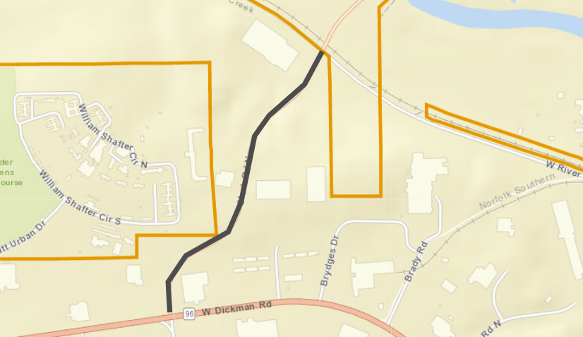
- Monday, Oct. 3-Friday, Oct. 28 – Clark Road from West Dickman Road to River Road – Work includes replacing sidewalk ramps at the intersection of Dickman and Clark, milling the road surface and repaving, and repainting pavement markings.
The road will be open, but please expect delays.
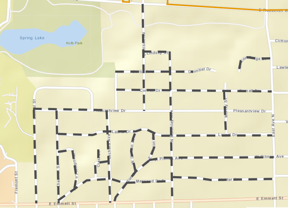
- Wednesday, Oct. 5-Friday, Oct. 7 – City contractors will sweep up the excess stones left over after our chip seal project earlier this year. Streets are open, and they will sweep stones from the streets, sidewalks, and around manholes.
Please do not park on these streets, when possible, so it is easier for the sweepers to get through.
- Beacon Ridge Drive – East Avenue N to end
- Central Street – Emmett Street E to Pleasantview Drive
- Chestnut Street – Emmett E to Pleasantview
- Clinton Drive – Emmett E to Laurel Drive
- Clinton Drive E – Pitman Avenue W to Laurel
- Cornell Drive – Orchard Avenue to East Avenue N
- Crest Drive – Orchard to Merwood Drive E
- Crest Lane – Crest Drive to end
- Curtis Avenue – Orchard to end
- Garrison Road – Roosevelt Avenue E to Pleasantview
- Hunter Street – McKinley Avenue N to East Avenue N
- Laurel Drive – Chestnut to East Avenue N
- Lindsey Street – Garrison to McKinley N
- McKinley Avenue N – Lindsey to Emmett E
- Merwood Drive E – Chestnut to McKinley N
- Morley Street – Laurel to Cornell
- Orchard Avenue – Emmett E to Pleasantview
- Pitman Avenue W – Clinton Drive to East Avenue N
- Pleasantview Drive – Central Street to Orchard
- Woodmer Lane – Chestnut to Merwood Drive E
See current/ongoing work projects from the Department of Public Works on our interactive work map. Find it at battlecreekmi.gov/publicworks, or at this direct link: https://battlecreekmi.maps.arcgis.com/apps/webappviewer/index.html?id=8bcd8770654d4e1fb8b3141be056d3e1.